
A Blog Post by Christopher Tenny
Sanborn Fire Insurance Maps as a Resource of Historic Research:
What They Are, How They Have Changed Over Time, Where to Find Them, and How to Use Them
Historic photographs, city directories, and birds-eye images (aerial photographs and maps) each reveal important information about historic buildings. Historic photographs depict the historic form, construction, and architecture of a building; city directories document the address, occupancy, and function of a building; and birds-eye images illustrate the spatial organization of structures, cityscapes, and landscapes. But is there a historic document that informs historians with the knowledge gathered separately from historic photographs, city directories, and birds-eye images?
Sanborn Fire Insurance maps combine the documentary power of historic photographs, city directories, and birds-eye images and as such offer immense value to historians interpreting the history of American cities, towns, and crossroads from the late-19th century through the beginning of the second half of the 20th century. Here at the South Carolina State Historic Preservation Office, our staff frequently analyzes Sanborn Fire Insurance maps either through select microfilm records available at the Department of Archives and History or through one of the many convenient, third-party online repositories (please continue reading this blog post for more information on where to access these resources).
Whether staff are tasked with evaluating eligibility for and facilitating nominations for listing to the National Register of Historic Places, certifying rehabilitation projects earning tax incentives on historic properties, administering grants for work ranging from stabilizing to rehabilitating historic properties, or reviewing the affect of and compliance with law of governmental undertakings on historic properties, SHPO staff turn to Sanborn Fire Insurance maps for a snapshot of the historic built environment at a particular time and place. These are just a few examples of how Sanborn Fire Insurance maps are a critical resource in identifying the character-defining features and historic character of a property during its period of significance.
History of the Sanborn Map Company in South Carolina
In South Carolina and across the nation, the late-19th century was a period of industrialization and urbanization. With these developments, new building materials, construction technologies, and methods of analyzing the built environment were introduced to the public. Around 1866, the Aetna Insurance Company of Hartford Connecticut contracted civil engineer Daniel Alfred Sanborn (b. 1827-d. 1883) to draft maps that could be used to assess the risk of fire across areas of urban development in Boston, Massachusetts and Tennessee. In 1867, Sanborn, quickly realizing the value of fire insurance maps, founded a company to create similar maps of places around the United States. By the end of the 19th century, the Sanborn Map Company, had become one of the largest firms in the nation creating fire insurance maps.
In the early 1880s, the Sanborn Map Company charted some of its first places in South Carolina. The Sanborn Map Company produced maps of crossroads as small as Cowpens and of cities as large as Charleston. While Charleston and comparably-sized cities were mapped frequently at a rate of roughly every decade or two, locations with small population sizes and minimal urban development were mapped much more sporadically, sometimes even only once. Unfortunately, for historians interpreting very rural places, the Sanborn Map Company rarely, if ever, charted remote, sparsely developed locations (often because the risk of fire spreading was minimal in these scattered areas). The Sanborn Map Company continued to produce maps of South Carolina areas until around the 1960s when insurance companies began to see diminishing economic returns on the product.
Because of the size of the areas covered and the requirement for a great amount of detail in Sanborn Fire Insurance maps, they were rarely (only for very small locales) a single map on one sheet but were instead usually many sheets of maps bound together as one book. Each sheet within a book typically depicted a few city blocks within the broader urban context.
Evolution of the Sanborn Fire Insurance Maps: Study the Map Key and Index for Different Maps
Throughout the Sanborn Map Company’s existence, Sanborn Fire Insurance maps evolved alongside the advent of new construction materials and changes in society. Given the modifications in the Sanborn Fire Insurance maps over time, it is important to always study the map key and index associated with a particular map (see below for an explanation of Sanborn Fire Insurance maps’ keys and indices).
Contemporary Collections of Sanborn Fire Insurance Maps
As time advances forward, historians increasingly appreciate the documentary worth in Sanborn Fire Insurance maps. Today, historians in South Carolina use both hardcopy books and digital books of Sanborn Fire Insurance maps available at a number of institutions online and at brick-and-mortar buildings such as these below (the most complete and convenient collection is held online at the University of South Carolina and the Library of Congress websites; both online repositories are free to use):
Available at brick-and-mortar locations:
- Local libraries
- Historical societies
- South Carolina Department of Archives and History
Available online:
- University of South Carolina Digital Library
- Library of Congress
- ProQuest (subscription required; offers a wide selection of Sanborn Fire Insurance maps)
Using the Sanborn Fire Insurance Maps for Historical Research
As an example, consider the May 1884 Sanborn Fire Insurance map of Charleston. This map can answer a wealth of questions, including but not limited to:
What were the names of streets and the addresses of different buildings in this area at that time? What were the functions (and in some cases, the occupants) of those buildings? What materials were used to construct the structural walls and roofs of those buildings? What were the window and shutter patterns of those buildings? How many stories tall were those buildings? How far apart were those buildings from each other? Did these buildings have porches? What were the footprints (form/outline in plan view) of those buildings? Were the property boundaries of those buildings delineated by a wall or other border? Were there outbuildings or auxiliary structures on the site? Were there other features in the vicinity, such as fire hydrants, docks, wharves, railroad tracks, alleyways and lanes? These questions and many more can all be answered through an examination of a Sanborn Fire Insurance map.
Step 1 in Using the Sanborn Fire Insurance Maps for Historical Research: The Index Sheet
Before using a Sanborn Fire Insurance map for historic research, one must first turn to the map set’s index sheet to understand its symbols, codes, and organization. Figure 1 (below) is the index sheet of the May 1884 Sanborn Fire Insurance map of Charleston:
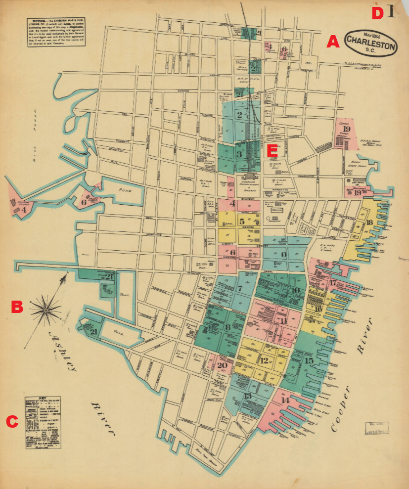
A stamp, marked on Figure 1 with the red letter “A” (added for educational purposes by the author of this blog post), identifies this map as the one covering Charleston in May 1884. Please note, however, that because some original Sanborn Fire Insurance map books were revised years later with taped-in or otherwise attached pieces of paper recording changes to the index sheet or detailed map sheets, researchers should verify with the collection’s metadata whether the map book being used for historic research is the original edition or a revised copy.
The compass rose, marked on Figure 1 with the red letter “B” (added for educational purposes by the author of this blog post), orients the Sanborn Fire Insurance map in the direction of north. Please note, Sanborn Fire Insurance maps are not always oriented with north pointing to the “top” of the sheet (sometimes the north direction points to the “right”, “left”, or “bottom” of the map), so it is important to familiarize oneself with the orientation of the cardinal directions in respect to the map sheets.
The map key, marked on Figure 1 with the red letter “C” (added for educational purposes by the author of this blog post), defines the symbols, colors, and other representative code-based visuals printed on the detailed map sheets (the map book’s large scale map sheets focusing in great detail on groupings of a few city blocks). Figure 2 (below) is the map key to the May 1884 Sanborn Fire Insurance map of Charleston):
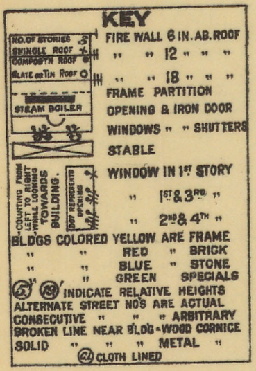
The map key above defines the different symbols and notations of the May 1884 Sanborn Fire Insurance map. According to the map key, the document’s detailed map sheets exhibit graphic information representing details like roofing materials, the height of fire wall projections above roof surfaces, frame partitions, door openings and materials of doors, building use (i.e. stables), window arrangements on particular floors, construction materials of the structure (i.e. brick, stone, wood-frame, concrete block), cornice features, and more. Please note, Sanborn Fire Insurance map keys are not all the same and therefore it is recommended to always utilize the map key associated with the particular map document.
The sheet number, marked on Figure 1 with the red letter “D” (added for educational purposes by the author of this blog post), is typically found in the upper-right hand corner of the document. According to the sheet number printed on Figure 1, sheet 1 is displayed.
Comprising the majority of the index sheet is the index map to the map book itself. The index map displays the geographic scope of the entire map set and also divides that whole area into color-coded territories of the map. Within the bounds of each color-coded territory, a numeral is printed which indexes that area of the map to the sheet number of a detailed map sheet in the map set.
For instance, the green color-coded area in the upper-central part of the index map, marked on Figure 1 with the red letter “E” (added for educational purposes by the author of this blog post), exhibits the numeral “3” within its shaded area. The number “3” beside this green color-coded area indicates that that territory is displayed on the detailed map of sheet 3 in the map book.
Step 2 in Using the Sanborn Fire Insurance Maps for Historical Research: Detailed Map Sheets
Now that the index sheet, the map key, the cardinal orientation, and the organization of Sanborn Fire Insurance maps have been explained, let’s explore the property of the William Aiken House, located at the south-east corner of the intersection of Ann and King Streets in Charleston, as it was around May 1884.
Figure 3 (below) is the detailed map of sheet 3 which includes the William Aiken House property (the red box has been added for educational purposes by the author of this blog post to highlight the location of the William Aiken House on this sheet):
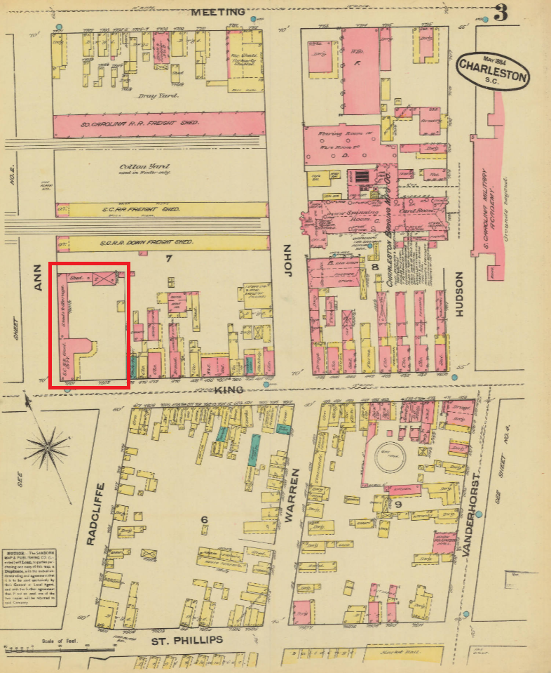
Figure 4 (below) is a zoomed-in view of sheet 3, focusing on the William Aiken House:
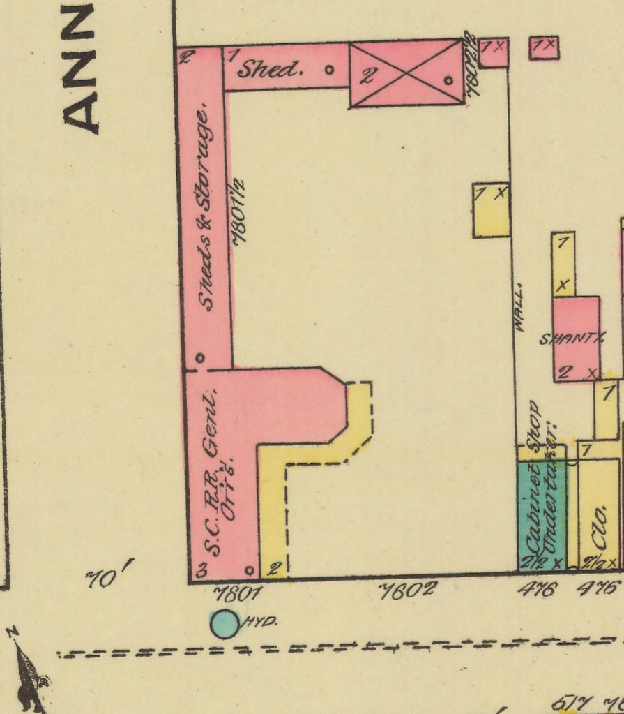
In the center of Figure 4, sits the walled William Aiken House property as it was in May 1884. According to the printed text in front of the site, the property was then known as “7801 and 7602 King Street”. At the time of the drafting of this Sanborn Fire Insurance map, William Aiken, Sr. (b. 1779-d. 1831) had been dead for over 50 years and the building that was once his residence was then occupied by the offices of the company he established, the South Carolina Railroad. Within the footprint of the main house, the text reading “S.C. R.R. Gen’l Offs” expresses that the structure was then occupied by the general offices of the South Carolina Railroad Company.
According to sheet 3 of the May 1884 Sanborn Fire Insurance map, the William Aiken House property was the only property located within that section of Upper King Street that had a wall encompassing it at the time. Figure 4 exhibits the building footprints (plan view form of a structure) of the different structures within this wall: along the eastern edge of the property (top of image), was a shed, a stable (refer to the map key for the symbol used to denote stables), and a small outbuilding and within the wall along Ann Street (left side of image) was a long structure housing sheds and storage.
The Sanborn Map Company color-coded the different structures on the William Aiken House property, depending on their wall structure’s material, either pinkish-red or yellow. The map key (Figure 2) respectively defines pinkish-red and yellow color-coded structures as solid brick or wood-frame construction. In the corner of each structure’s footprint, a small number represents the number of floors within the structure. Also within the footprint of most structures, a small circular symbol symbolizes the material of the structure’s roof.
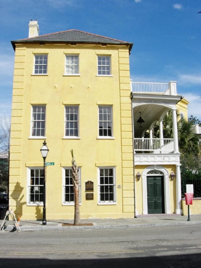
For example, according to sheet 3 of the May 1884 Sanborn Fire Insurance map, the main building of the William Aiken House property is a structure with an L-shaped plan that is color-coded pinkish-red, has the number “3” within its pinkish-red footprint, and has an unshaded circular symbol within its pinkish-red footprint. Wrapping around the L-shaped plan of the pinkish-red structure is a yellow color-coded structure with a dashed-perimeter and the number “2” in its yellow footprint. The map key (Figure 2) defines these symbols as signifying that the main house was a three-story tall, solid brick building with a tin or slate roof and a 2-story, wood-frame, wrap-around porch (or as Charlestonian William Aiken, Sr. called it, a “piazza”) with a wooden cornice.
A Preserved Document, With an Adaptive Re-Use
Given that the original purpose of such maps was to assess fire risk, it is worth noting that the map documents the location of a fire hydrant on King Street directly in front of the William Aiken House. Elsewhere on sheet 3 of the May 1884 Sanborn Fire Insurance map of Charleston (beyond the scope of the zoomed-in image of Figure 4), the Sanborn Map Company recorded a fire alarm box, a gas tank, and across King Street from the William Aiken House, land heavily concentrated with wood-frame structures; all of this information was of great interest to contemporary insurance companies intent on calculating fire insurance risks and premiums.
While Sanborn Fire Insurance maps were originally intended to aid the assessment of fire risk by insurance companies, modern historians study these maps for their unrivalled documentation of the historical addresses, sizes, functions, construction materials, and geospatial distribution of structures. This information together, as demonstrated, is akin to using historic photographs, city directories, and birds-eye images in tandem. With all of this information, one must wonder: how reliable are Sanborn Fire Insurance maps? Let the below c. 2000 image of the preserved William Aiken House convince you that the May 1884 Sanborn Fire Insurance map’s depiction of the structure as a 3-story, solid-brick building with a slate roof and a two-story, wood-frame, wrap-around porch with a wooden cornice is an accurate historic illustration of the structure: