

A Blog Post by Christopher Tenny
History and geography go hand-in-hand like the state flag’s Palmetto and Silver Crescent. Consider the National Register of Historic Places (NRHP) – its name, and even its evaluation of historic integrity, underscores that history is rooted in location and setting. Keeping track of a few historic sites, their locations, and their associated information may be manageable on a paper map but how does the South Carolina Department of Archives and History manage to keep track of the geography of thousands of historic sites and survey areas spanning a whole state? The answer: SC ArchSite.
What is SC ArchSite?
SC ArchSite is an online Geographic Information System (GIS), or digital map, that combines information about historic properties from the South Carolina State Historic Preservation Office (SC SHPO) and archaeological site information from the South Carolina Institute of Archaeology and Anthropology (SCIAA). Its development benefitted from funding support from the South Carolina Department of Transportation (SCDOT), and technical support from the University of South Carolina Department of Geography. Federal and state agencies, academics, consultants, preservationists, and the general public use SC ArchSite to interpret the geospatial relationship between cultural heritage resources and other resources in South Carolina, such as infrastructure, waterways, landscapes, development, and more.
SC ArchSite plots the recorded historic resources, such as NRHP properties, archaeological sites, and cultural resource survey areas, of South Carolina on a computer-based map of the State that can be digitally overlaid with various basemaps illustrating transportation routes, geographical features, and other geospatial references. This digital document lives in cyber space at http://www.scarchsite.org/default.aspx and is updated multiple times a year as historic resources are identified, surveyed, and evaluated.
There are two modes of viewing SC ArchSite: Public View and Subscriber View.
Public View mode is free, requires no account, and is intended for the general public’s use. Public View displays only non-restricted above-ground historic and architectural resources; all archaeological sites and restricted NRHP properties are not visible to viewers using the Public View. To access the Public View type of SC ArchSite please visit http://www.scarchsite.org/PublicView.aspx.
Subscriber View mode is intended for professional, governmental, or academic use; users include cultural resource professionals, environmental consultants, planners, and government agencies. Users must log-in through a secured account to use the Subscriber View mode. In addition to all the information available in the Public View mode, Subscriber View also provides access to restricted cultural resource information such as archaeological sites and restricted NRHP properties. . All organizations requesting Subscriber View access must sign a License Agreement and complete the Subscription Request Form accessible through SC ArchSite.
More information on the fees, account creation, and benefits of Subscriber View access can be found at http://www.scarchsite.org/overview.aspx.
What’s in SC ArchSite?
SC ArchSite provides a dozen different basemaps (only 2 basemaps in Public View mode), or background cartography, ranging from simple street-focused maps to organizationally-published maps.
Overlaid on the basemaps, SC ArchSite plots tens of thousands of shapefiles (digitally-drawn map points or polygons marking or outlining georeferenced locations) for different sets of cultural resource layers on the basemap. These layers of cultural resource features, from survey areas to NRHP-listed properties to NRHP eligible properties, are depicted with unique symbols; for example, single historic structure sites determined individually not eligible for the NRHP are identified on SC ArchSite as pink dots whereas single historic structure sites determined individually eligible for the NRHP are identified on SC ArchSite as purple triangles.
Public View basemaps:
- Street map
- Satellite map
Public View layers:
- NRHP-listed points (single site)
- NRHP-listed polygons (districts and complexes)
- NRHP eligible historic structures
- NRHP not eligible historic structures
- NRHP eligible districts
- NRHP not eligible districts
Subscriber View basemaps:
- Public View basemaps + 10 other basemaps (topographic, oceanic, satellite with labels, light gray canvas, dark gray canvas, USGS map, National Geographic map, et cetera)
Subscriber View additional layers:
- Public View mode layers
- Civil War earthwork points
- Archaeology points
- Archaeology sites (including access to Site File records)
- Restricted-access NRHP-listed points (single site)
- Restricted-access NRHP-listed polygons
- SHPO covenants
- Cultural resource survey lines
- Cultural resource survey areas
How do I use SC ArchSite?
Public View Mode
For Public View mode, proceed to http://www.scarchsite.org/default.aspx and navigate to the link “Public View Map” at the top of the webpage banner. Selecting this link will load the Public View map.
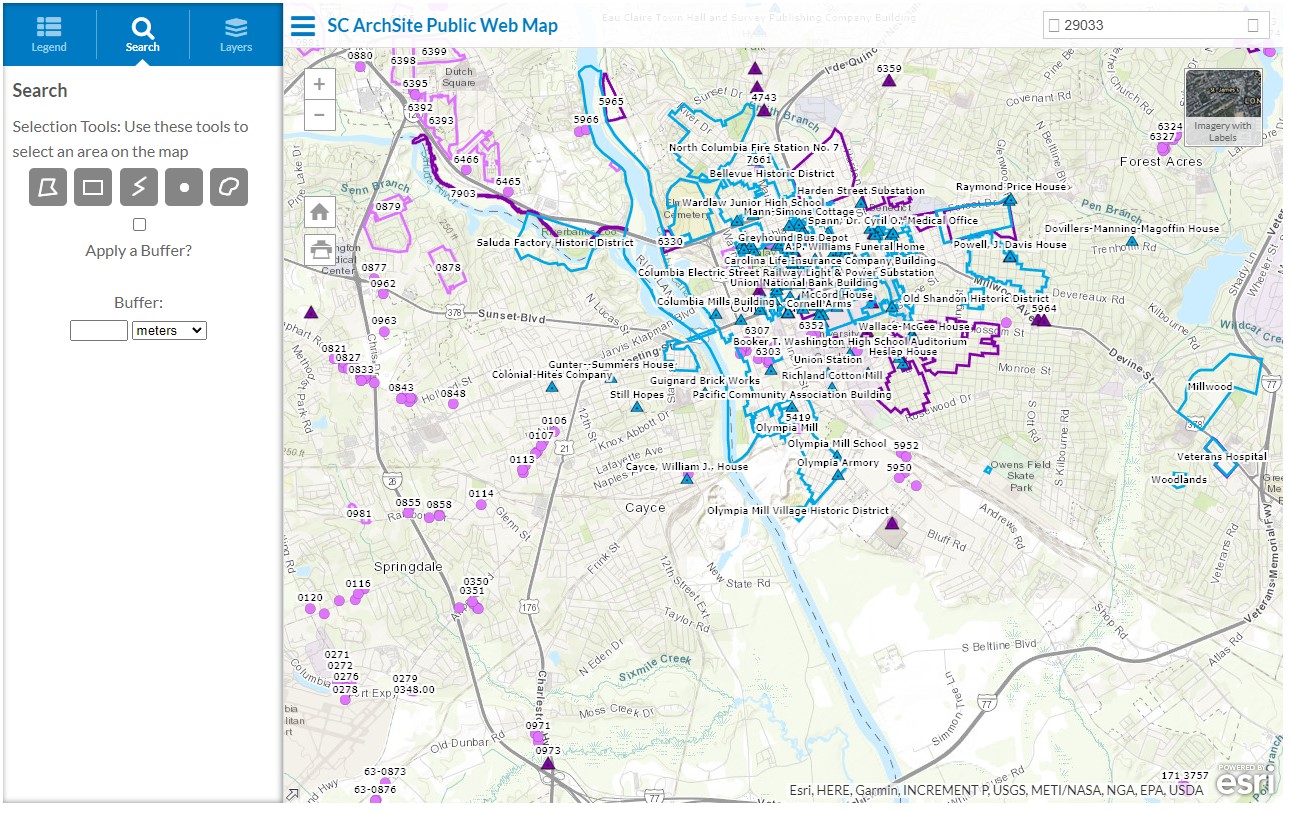
Image of the Public View mode map window.
At the top right corner of the Public View, a small thumbnail of satellite imagery or a street map allows users to switch the background between these 2 basemaps. If the background of the GIS displays the street map, the thumbnail in the top right corner will display a satellite image which upon being clicked will render the background as aerial photography. On the other hand, if the background of the GIS displays aerial photography, the thumbnail in the top right corner will display a street map which upon being clicked will render the background as a street map.
Navigating the GIS is as easy as panning the map display area by holding on the left-mouse button and dragging the screen. Additionally, the GIS offers tools for searching and selecting features on the map.
At the top right of the GIS map, is a text box that allows users to input city, Zip Code, or other location referencing information. Hitting enter once location information has been input into the textbox will center the map screen on that location in South Carolina. At the top left corner of the map is a menu icon (three stacked horizontal lines) beside blue text titled “SC ArchSite Public View.” Selecting this menu icon will either open or close the menu field window, depending on whether it is open or closed already.
The menu field window, when open, contains three tabs: Legend, Search, and Layers.
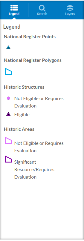
Image of the Public View mode map legend.
The left-most and default tab, the Legend tab, is a key which displays each symbol associated with every feature type. If the legend is blank, zooming in on the GIS map will populate the legend with these symbols.
The middle tab, Search, provides users with the ability to use different draw-selection tools to identify shapefiles on the map. The search function also allows integrating a “buffer” into the selection, enabling for a wider-cast on the selection to identify more shapefiles.
The right-hand tab, Layers, permits users to check boxes toggling on and off which features, or layers, are plotted on the map. For instance, if one was interested in observing the geospatial relationships of only the NRHP-listed sites, then they could uncheck the boxes of layers for the other features.
Subscriber View Mode
The Subscriber View Subscriber View offers all of the abilities that the Public View mode provides, plus:
- Full array of layers (archaeological layers, restricted NRHP sites, and much more, including physiographic regions)
- Full array of basemaps
- Real-time adjusting scale size of the GIS map
- Surface area and distance measurement tools
- Similar selection tools as Public View, including buffer selection tool
- Export data tools, to export and save selected shapefiles, geodatabases, and more
- Printer options
- Expanded search options, including search by site number, survey title, and much more
In terms of navigating the GIS, the Subscriber View functions similarly to the Public View mode but with much more capability and functionality. This brief blog post could not reasonably illustrate all the steps of performing tasks in the Subscriber View mode. Fortunately, SC ArchSite has published helpful tutorials for both the Public View and Subscriber View modes. Please visit this link to access video tutorials and user guides with text and images for both the Public View and Subscriber View SC ArchSite modes: http://www.scarchsite.org/userDoc.aspx.
Visit and Explore!
The SC SHPO invites you to explore SC ArchSite and to discover more about the geography of the state’s recorded cultural resources. If you have further questions about SC ArchSite, please do not hesitate to contact Christopher Tenny (803-896-5638).